CBCS PhD candidate
Professor Catherine Lovelock
ARC Laureate Fellow and Head,
Mangrove and Blue Carbon Lab, CBCS
Their persistence with sea-level rise depends upon their capacity to increase their soil surface elevation at a rate comparable to the rate of sea-level rise, otherwise they will eventually drown. We set out to understand whether coastal wetlands in Moreton Bay can persist with sea-level rise and the processes that make this possible.
Mangroves and saltmarshes
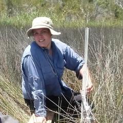
In 2007, we installed 36 instruments called rod-surface elevation tables (RSETs) to monitor soil surface elevation dynamics at six sites in the mangroves and saltmarshes of Moreton Bay. The concept of measuring soil surface elevation using RSETs was developed by the United States Geological Survey in the 1990s.
It has been adopted worldwide since then, with over 20 countries using RSETs to measure soil surface elevation change in a wide range of coastal wetlands, answering fundamental questions about their resilience to sea-level rise. The device measures the precise changes in soil surface elevation using a stable benchmark anchored deep in the soil.
RSET benchmarks consist of stainless- steel rods hammered into the sediment (~12m deep), which are capped with cement at the soil surface. Installation of RSETs can be difficult, as you balance on a platform while hammering so as not to disrupt the soil surface that you plan to monitor for the next decade or longer. The changes in elevation of the soil surface are measured using a portable measuring “table” that is attached to the rods. Levelled and fibreglass pins are carefully lowered to the soil’s surface.
In addition to soil surface elevation, we have made a range of other measurements including surface accretion (measured as sediment trapped on the surface) and mangrove tree growth using dendrometer bands that measure growth of the circumference of tree stems.
We found that the dynamics of soil surface within these ecosystems are complex, as there are biotic and abiotic factors that interact to influence trends in soil surface elevation. Using an analytical technique called structural equation modelling, we identified that trends in mangrove soil surface elevation were more strongly influenced by variations in biotic factors than abiotic factors.
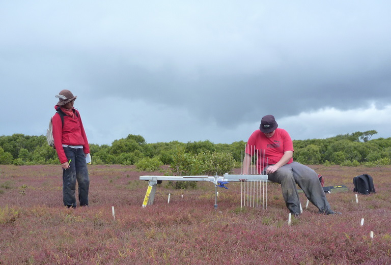
Photo credit: Catherine Lovelock
Gains in soil surface elevation were greater with the presence of the stilted mangrove Rhizophora stylosa than with the dominant species in Moreton Bay, the grey mangrove Avicennia marina. Soil surface elevation gains were also higher with high levels of soil turnover by crabs. However, annual rainfall was linked to sediment trapping in the mangroves, reflecting the role of high rainfall in sediment runoff into the Bay, of which a portion is trapped in the mangrove. Increased annual rainfall also supported increased levels of mangrove tree growth.
Although mangroves live with daily inundation by saline tidal waters they rely on fresh water for high growth rates. We also found that stilted mangrove trees have faster growth rates than those of the grey mangrove. Global warming may be enabling the stilted mangrove to increase its abundance in Moreton Bay, which ultimately may enhance the resilience of mangroves to sea-level rise.
Gains in the soil surface elevation within the saltmarshes of Moreton Bay were much less than that observed in the mangroves, and were directly influenced by variation in annual rainfall. The trapping of sediments in the saltmarsh was also influenced by annual rainfall (similar to mangroves) and by plant cover, suggesting that dense plants slow water flows, leading to the deposition of sediment suspended in tidal waters within the saltmarsh. Our ongoing monitoring of the coastal wetlands of Moreton Bay is enabling us to gain a better understanding of potential tipping points of these systems with extreme El Niño Southern Oscillation (ENSO) events and with sea-level rise.
Not for the faint-hearted, but joy-filled
Field work within these ecosystems isn’t for the faint hearted, but for those tenderly touched by the love of mud, it’s all in a day’s work.
Like most field work, it has its challenges and ups and downs, but knowing we are gathering some of the most important baseline data on how wetlands of Moreton Bay respond to sea-level rise and other threats brings us great joy. While our data has not yet captured the impacts of sea-level rise on landward migration of mangroves into saltmarshes, by returning to the same sites over all these years we have watched the mangroves colonise the saltmarsh at Tinchi Tamba Wetlands. In the Boondall Wetlands, we have to argue with a mangrove tree growing laterally into one of our saltmarsh plots that now requires us to adopt yoga poses to measure the RSET – and many other saltmarsh sites are bursting with an abundance of young mangrove saplings. Our monitoring is set to deliver rich insights into the changing state of Moreton Bay’s wetlands as climate change progresses.
Reference: Bennion, V., Dwyer, J.M., Twomey, A.J., & Lovelock, C.E. (2024). Decadal trends in surface elevation and tree growth in coastal wetlands of Moreton Bay, Queensland, Australia. Estuaries and Coasts. https://doi.org/10.1007/s12237- 024-01325-y
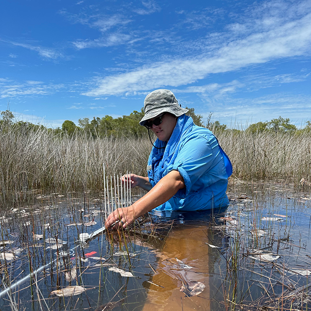
Photo credit: Catherine Lovelock
Read more of these stories in Issue 18 of the CBCS Newsletter and follow us on X (Twitter) and LinkedIn.